Sunday February 26, 2017

Boulder Hut 03-10-2013

March 21, 2013 Tags: skiing boulder hut

I had another great week up at Boulder Hut Adventures. The week started out with a blue-bird day Monday. We headed up to Brin’s Bump for a run and we ended up skiing it twice because it was so good.

Check out video of Rick skiing on the second run.

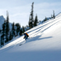
For Tuesday and Wednesday, we had new snow and lots of powder tree skiing. This was some of the best skiing on the trip. In fact the skiing was so good, I left my camera at the hut and just enjoyed the 2 days of climbing and skiing, and climbing and skiing, and …

Unfortunately, on Thursday, we woke up to rain at the hut. A group of us took the day off. I expected the next few days to be really crappy skiing. But the snow up high turned out to be in decent condition. On Friday we made it up to Boulder Pass and spent the day searching for good skiable snow and we managed to find some.

It was supposed to snow Saturday afternoon, so we decided to a little exploring up high in the morning. We went up to Porcupine Ridge in the morning for some views. The snow ended up coming in early we ended up spending the rest of the day lapping the runs in the Lakes District.

show picture of everyone at last run

It was another great group of guests at the Hut this year.The staff was amazing and as usual the food was one of the highlights of the trip. I am looking forward to next year.

Other Pictures

Paradise to Camp Muir on 02-02-2013

February 02, 2013 Tags: skiing Mt Rainier rainier

On Saturday, we had another amazing sunny day. I headed out to Mt Rainier National Park. I went up the Muir snowfield to Camp Muir. This was not the smartest plan, 5000+ ft and 4.5 miles of climbing in new ski boot liners produced just a bit of discomfort. I Should have been smart and stopped 1/2 way up.

On the way up, I bonked about 1/4 mile from Camp Muir and decided to fight through it….. bad move. I Should have stopped and ate something. I was really wiped out when I got the Camp Muir and for the ski down.

The skiing up high was messy. Mixture of hard crust and 2 ft of wind blown powder; every turn was a mystery. The middle section was nice. The bottom was crusty, but skiable.

Other Pictures

Tamanos Mt 07-28-2012

July 29, 2012 Tags: hiking rainier

Last year, I hiked up to Owyhigh Lake on a cloudy, drizzly day. I decided it was time to go back on a clear day to see the sights and to climb Tamanos Mt.

This is a beautiful hike. You for go up through old-ish forest (ie big trees, little understory) and end up in meadows and a beautiful lake. The trail is in great condition and makes the steady climb up to the lake feel easy.

I got to the trailhead early-ish and was one of the only cars in the parking lot. I passed a few backpackers on their way out, but did not see another soul till I was coming back down of Tamanos Mt.

I made it up to the lake in about 1.5hrs. The flowers are just starting now. By next weekend, they will be in full bloom. I had a quick bite to eat at the lake and then headed up to the pass where the trail up Tamanos Mt starts.

The trail heads up to a saddle below Tamanos Mt. The views are spectacular, Rainier, ofcourse, and good views of Mt Adams and Goat Rocks. There is a pretty good trail up from the saddle the peak, with only a quick, little scramble at the end.

The views all along the way were stunning and the flowers were blooming up here too. When I got to the top, I could see the marine layer was still covering the low-lands. I was happy I choose this side of Rainier as I had nothing but clear, blue skies all day long.

Other Pictures

The Jackson Tour -- 05/26/2012

May 29, 2012 Tags: skiing backcountry

For over a year now, I have been hearing about the Jackson Tour. This past weekend Garrett (the Jackson Tour’s namesake), Rick and I decided to go and give it a try. It turned out to be a great decision. The Jackson Tour is a loop trip through 3 passes near the North Fork Teanaway.

The trip did not start out all that promising. A big patch of snow blocked the Teanaway Road about 1/2 mile from the Iron Peak trailhead. Skis on our packs, we headed down the road to the trailhead. We ended up hiking up the Iron Peak trail for about 1000ft vertical before we found continuos snow and could put the skis on.

We skinned up to the pass below Iron Peak. At the pass we had a fantastic view into the Beverly Creek drainage.

We skied down from Iron Peak in the Beverly Creek drainage and then headed north to the Beverly-Turnpike pass (pass #2). Where we got our first views of Mt Stuart and rest of the Stuart range. It was great ski down one of the gullies to Turnpike Creek.

From there we headed up towards Longs Pass. It was pretty easy going up a beautiful valley (and a view all the way into eastern washington). We headed towards Longs Pass and ended up finding a nice cornice free spot just a little bit down the ridge from pass. We spread out and headed up and over the ridge one at at time. Despite being late in the day, the snow was very stable.

We had 2nd lunch on the ridge top, until we noticed the very dark clouds coming our way and quickly got on our way. We had to down-climb about 20 yards from the top of the ridge to find snow. It was a fantastic ski down the open slopes and the woods to the Ingalls Lake trailhead.

We were able to ski the road for about a mile, but then had to put the skis back on the pack and walk back to the car.

The snow conditions were stable all day long. There was evidence of some large cornice releases and wet slab avalanches from prior days. We ended up seeing maybe 10 people the entire day and we had the Beverly and Turnpike creek drainages all to ourselves.

Other Pictures

Grand Canyon (Day 2) -- 11/19/2011

November 29, 2011 Tags: backpacking hiking

View across the Colorado from our camp

[Trip report for Day 1]

The 2nd day of the trip was spent getting from Horseshoe Mesa to the mouth of Red Canyon (and Hance Rapids).  For some reason both Garrett and I thought that this would be much shorter trip than it is. We got in the morning planning to do a bunch of exploring on Horseshoe Mesa and in the canyons on our trip. 

However, we quickly realized that it was 8.4 miles to our next camp and we decided lolly-gagging on Horseshoe Mesa will need to wait till another trip. 

Garrett emerging from the mine...

We headed out down the Tonto Trail. The first order of business was down to Page spring to get some water.  We saw two groups of hikers between the mesa and Hance Creek (probably the first 2 miles of the hike) and did not see another person until we got to camp. (which was fantastic)

Garrett at our lunch spot

The hiking was great, we had a beautiful sunny day with constant and strong winds. We lunched below Ayer Point with great views and only a few winds blasts.

We crossed Mineral Canyon and eventually got our first views of Colorado and and glimpse of why this area is called Red Canyon.

We finally made it down to the river at by about 4pm and found a great campsite. Here is Garrett rejoicing on our arrival

Other Photos


Grand Canyon (Day 1) -- 11/18/2011

November 26, 2011 Tags: backpacking hiking

View from the top of the Grandview Trail

Garrett and I went to the Grand Canyon for a very quick 3 day backpack in late November. It was a very quick trip to this amazing place (way too quick).  We lucked out and got great weather and had an fantastic trip.  

Day 1 was a friday. We flew Phoenix from Seattle on a ridiculously early flight.  In Phoenix, we rented a car, headed to Flagstaff to pickup the food and other supplies we needed. And then on the south rim of the Grand Canyon.

This all took much longer that we had optimisitically hoped it would.  We ended up getting to the Grandview trailhead around 4pm and did not start down till 4:30pm (2 hours later than we hoped).

Our campsite

As you would expect, we got our campsite on Horseshoe Mesa in the dark.  We made some dinner and spent the evening playing with long exposure shots.

The next morning, we got up early and got to see all the views from our campsite. They were impressive. As we lounged around drinking coffee and taking pictures we started discussing our schedule for the day. 

>The view from our campsite

For some unknown reason, we both thought we had about 5 miles to our next campsite, so we started planning some side trips.  But as I was looking at the trail description, I realized it was actually 8.4 miles to our next camp at the base of Red Canyon. We ended up heading straight down the river, without any side trips. Those were left for the next trip.

See the next blog entries for on day 2 or 3.


Other Photos:


Backpacking near Volcanic Peak -- 07/23/2011

August 02, 2011 Tags: backpacking hiking

Bill, Rick and Steve on the way up to Volanic Neck.

Steve flew out from Montreal for a quick visit and wanted some "alpine bliss".  So Bill, Rick, Steve and I headed to Teanaway area for an overnight backpack on Saturday. We had beautiful weather for both day. During the weekend, we essentially circumnavigated Bean Peak. 

Bean creek basin

We headed up the Bean Creek trail to Bean Creek Basin. And then up and over the ridge to the Fourth creek drainage. On the way up, we had good views of Mt Adams. At the top of the ridge, we got great views of the Ingalls Creek and the Enchantments beyond. 

Fourth creek and the Enchantments

After some lounging around on the ridge, we headed down into Fourth creek and to meet up with the County Line trail.  This took a little bit of cross country travel.

We then headed up of the ridge next to Volcanic Neck into the Turnpike creek drainage.  At the top of ridge we got fantastic views of Mt Rainer to the south and and Mt Stewart to the north. A great location for more lounging. 

Steve enjoying the view of Mt Stewart

We then headed down to set up camp, which was an big granite outcropping below Volanic Neck.  The campsite was fantastic with views of Mt Stewart and the Enchantments. 

We had a nice dinner, enjoyed the sunset and the stars. Overnight we had a bit of wind, but nothing too bae. On sunday, we headed back to the trailhead via the Beverly-Turnpike trail.

It was another great trip. The flowers were out and the bugs were not too bad (I only needed to apply bug juice once during the 2 days) Thank you guys for a great trip.


Other Photos:


today I am going home 03-16-2006

March 16, 2006 Tags: 3 month trip San Francisco

San Fransciso has been great! But for the past 2 days I have been feeling this very strong urge to head home. I am not sure why it started, but I think it had to do with watching Steve and Gary interacting with all of their friends. It made me realize how much I missed my social circle in Seattle.

Maybe you can call it the loneliness of traveling alone or maybe that I am tiring of experiencing things on my own. Who knows. Or maybe I am just looking forward to waking up in the same bed 2 days in a row.

I will be heading out right after the morning commute. Have an early lunch over in Emeryville with Dylan and then head north. There is a pretty good chance that I will be stupid and drive straight through. I know, I know it is 16 hours, but I have to keep my driving cred alive.

(Oh and Jim and Doug, sorry I was sort of hoping to have you guys bookend this travels, but maybe I will just have to come on out in April for a weekend of spring skiing. Sorry!)

58 days 03-16-2006

March 16, 2006 Tags: 3 month trip seattle

On Tuesday night at 2:30am, a tired and wobbly mascot finally made it back to Seattle.

58 days away from home. That is a record for me. It has been an amazing and rewarding trip. I met many great people and made many new friends. Thank you to everyone who helped me make this trip a fantastic one!

It is a strange feeling. I am happy to be home but at the same time sad that I am not exhausted, sitting on the bumper of my car pulling off my ski boots.

mascot meets it's maker

March 14, 2006 Tags: 3 month trip san francisco

On Tuesday, March 14th, I stopped up at the Pixar offices to meet up with Dylan. Dylan used to live here in Seattle and has just recently moved down to SF. Many years ago, I got a call from Dylan. He asked if I would come to lunch. Half way through lunch he plopped a box containing the mascot on the table in front of me. He proceeded to tell me the story of the creation of the mascot and it’s brethren. He was absolutely giddy with excitement (I will not relate the story here, if you want to hear it, buy me a beer someday and I will tell you. Or maybe Dylan has told it somewhere and will pass on the link to me.).

The mascot was originally designed to be a marketing give-away for Pixar’s Renderman Software at the Siggraph conference. If you do a search on google for “Pixar renderman walking teapot” and you will find lots of geeky entries on the first and subsequent years teapots. I have even seen them for sale on ebay.

While I was visiting Dylan, the mascot was finally able to meet others of his kind.

Dylan let slip that there will be a Walking Teapot retrospective at Siggraph this year. So if you are there, head over the Pixar booth and take a look. He also let me know that even though the mascot traveled ~7000 miles, from the tops of mountains to the deserts of Death Valley, there was one other teapot that has traveled farther. He showed me a picture of a Walking Teapot at the South Pole. The mascot was devastated.

P.S.: The Pixar offices are very nice. I got a quick tour and architectually they are pretty fantastic. Must be nice place to work.